Skip to content Transforming your infrastructure into living assets

Atlas InSAR – Monitoring

Regular and flexible updates of ground and structural motion evolution during all project phases

Atlas InSAR monitoring studies provide regular and flexible updates of ground and structural motion measurements during the construction, operation and maintenance phase of any site or project. From weekly to monthly, quaterly or yearly, the frequency of ground motion measurement can be easily adapted to the criticality of the project phase and project specific requirements and can be readjusted at any time. Atlas InSAR provides customised services, from rapid bulletins providing a quick overview of latest measurements to comprehensive studies following milimetric deformation associated to tunnelling advancements. Atlas InSAR is a robust, efficient and cost-effective monitoring solution to minimise and mitigate geotechnical risks.  

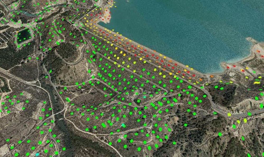
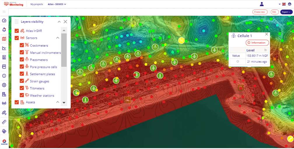
Measuring ground motion from space

Thanks to InSAR technology (Interferometric Synthetic Aperture Radar), the Atlas satellite solution allows for millimetric-precision measurements of ground, buildings or construction sites.

Measurements obtained from satellite cover vast areas without an on-the-ground intervention.

They provide a detailed analysis of the deformations on the terrain, which can be due to works carried out on it or other such events, understanding of the impacted area.

Our Atlas InSAR advanced processing chain can work with any current Satellite SAR Images.

Sixense teams can task SAR Satellites to acquire images over any site every few days to develop customised monitoring programmes designed to provide ground and asset motion information.

Different Satellites will be tasked depending on site and motion characteristics.

Atlas InSAR can work with X, C or L band to ensure the best information is used on each project.

New constellations are being launched and very soon daily imagery will be available for real-time satellite monitoring programmes at a fraction of the cost of traditional monitoring.

Monitor impact of construction works: drawing exact settlement contours

Atlas InSAR monitoring can be applied during the construction phase of any project, providing millions of measurement points with millimetric precision.

The area covered can always be larger that the defined Zone Of Interest, thus Atlas services are a perfect tool to settle subsidence claims and complement in-situ instrumentation.

Monitor tunneling activities: ground settlement due to volume loss

Atlas InSAR monitoring is particularly suited to monitor ground surface displacement resulting from tunneling activities and to measure its impact on existing buildings and infrastructures.

During tunnelling advancement, InSAR Atlas monitoring solutions are used to monitor ground settlement due to volume loss, verify surveying reference points and map any widening of the settlement outside the calculated ZOI.

Early warning tool: detect precursor motion to landslide and slope failures

Atlas InSAR monitoring is an efficient tool to detect precursor motion to landslides, slope failures along large areas such as highways, railways or pipelines and remote and critical infrastructure such as mines, tailing dams and bridges.

Non-linear motion or motion acceleration can be identified, enabling the implementation of early-stage mitigation interventions.

Long term smart maintenance

Atlas InSAR Monitoring is the perfect tool to design long term maintenance programmes.

It provides cost effective measurements and wide area coverage to assess structural health and detect motion likely to cause damages to infrastructures.

Risk Reduction in Mining and tailings dam

Atlas InSAR Monitoring allows customised monitoring programmes to support mining activity.

Atlas InSAR can monitor motion of both underground and open pit mining sites and be used to ensures stability of key infrastructures such as tailing dams, waste dumps and access roads.

The additional benefits of using our Atlas InSAR solution

A unique competence combining InSAR data and Ground Instrumentation data

Sixense is the only supplier offering this wide range of ground and space sensors and an integrated solution for the civil engineering industry.
Sixense has more than 700 engineers worldwide dedicated to the construction sector and holds more than 10 years of expertise processing satellite radar data. This gives us a deep understanding in the sector.

Atlas InSAR, a high quality processing chain

Sixense is always looking for new innovative solutions bringing added value to our clients and in 2004 we started developing our own InSAR solution to provide an additional response to the complex issue of ground deformation.
Atlas InSAR is in constant development to keep up with new opportunities offered by the unprecedented spatial and temporal volume of Synthetic Aperture Radar (SAR) data - this is only going to increase with new sensors in the future.

An advanced web platform

Beyond Satellite is able to transform data into actionable information, customised according to client needs, and using cutting-edge analytic tools.
Moreover, it offers the possibility to integrate in-situ monitoring measurements with Atlas results to provide clients with multiscale and holistic control for the different assets of interest.

Download the Atlas InSAR solution datasheet